Including Making Surveying and Scientific Instruments
Background
It's a long story. A friend wanted to build an all-wooden clock and I helped look for plans and information. Then he suggested that I'd enjoy a book called "Longitude" by Sobel. He was right, I did, but it also got me interested in navigation. I looked for a source for an inexpensive sextant for quite a while, but never found a good one I could afford. And of course I also read several books on sextants and navigation. Somewhere I read that surveyors also use celestial positioning and that the surveyor's or engineer's transit can make celestial observation measurements much like the sextant does. In fact, many older surveying textbooks have step by step instructions.
And in looking for information on sextants, and then also on surveying instruments, I read all the books I could get through the library system about antique scientific instruments. There are also a good number of web sites on these subjects, too. But I've found it a bad practice to include lots of links because they change too often and bad, broken links are probably worse than none at all.
Eventually I found plans on the web for a home made sextant and I've been gathering materials to try out the project. And I found many sources of cheap, imported brass reproductions of navigational and surveying and other scientific instruments. But I also saw many negative comments about their quality. I looked at a couple of sextants made in India while in a nautical gift shop, and they did seem not too well done. But, like in most things, you get only what you pay for.
My Instruments
I did finally gamble on the imported brass stuff and bought a pocket box sextant ($30) and an Abney level ($15) from Avesta Collectibles. They're actually quite decent, after a little work, and I'm very pleased with them and with the dealer.
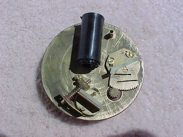
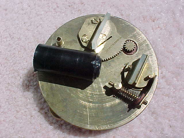
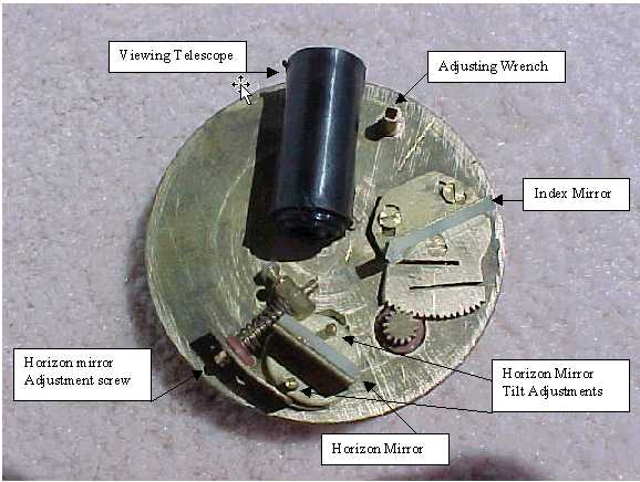
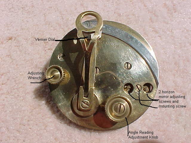
Like all sextants, the little box sextant needed initial alignment adjustment. And it also needed some mechanical fitting and adjustment. Pictures of inside of pocket box sextant: View_1 , View_2 showing parts locations for my modifications and improvements. And views of the inside and outside, with the parts and controls labeled. It works quite nicely, although the telescope optics are pretty poor. I don't know of a practical way to check its accuracy either.
The Abney level was closer to ready to use when it arrived, mainly just wanting some cleaning, but I did need to adjust the friction tension of the tilting scale joint. To do that I wound up smoothing the mating surfaces on very fine sandpaper lying on a smooth, flat surface. The mirror is just some polished brass, but it does show the level bubble. It even gives a nice, golden color. But it wasn't very bright, so I cut a little, tiny piece of mirror and glued it onto the metal mirror surface. The view of the bubble still isn't extremely bright, but it's better.
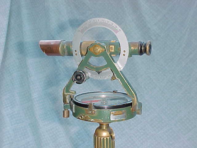
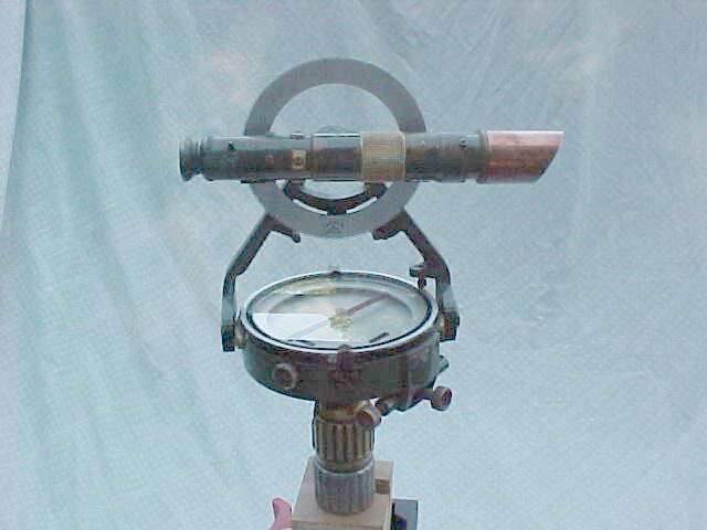
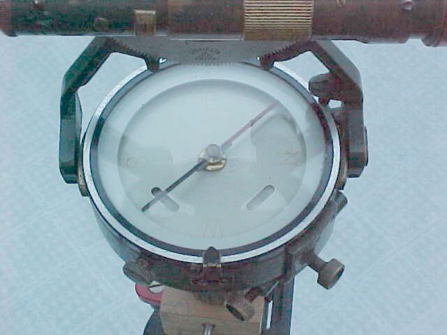
I found an old WW II instrument which the seller called a transit. Since then I've seen it called several different names. It's original Japanese manufacturer calls it a 'surveying compass ' and still has essentially the same thing in production as the Ushikata model S-25. The US importer (Sokkia) calls it a "transiting telescope surveying compass." The descriptions include "Fills the need for a small, light weight transit." And "Lightweight, compact surveying compass ideal for use where a small pocket transit is needed for general surveying." I haven't compared actual measurements yet, but the manufacturer's specs seem to apply to this old one as well. It has a 12X telescope with erect image, 4-3/4 inches long, with 1:100 ratio stadia measurement ratio. The vertical circle is graduated 50d - 0 - 50deg., top and bottom, and is moved with a knob and pinion gear. The horizontal circle is graduated in degrees, with vernier reading to 5 minutes. The compass has a declination adjustment. On my compass the dial scale has faded to invisibility, although I can faintly see the N, E, S, and W. The horizontal circle works like a transit, with a clamp screw and tangent screw for fine adjustment. The scale can be set with zero at any position, independent of the compass dial.
These seem to be ideal light, field transits for forestry, archaeology, anthropology, geology and other field sciences.
Pictures of Ushikata from left , showing the horizontal and vertical scales, from right and of the compass dial . Note my home-made sunshade on the telescope, made from a piece of 3/4 inch copper pipe.
I'm looking seriously at importing a similar telescopic compass from China, like this one except without the resettable horizontal angle-measuring scale. It should sell for around $200 to $250 if I'm lucky. PLEASE let me know if you're interested in getting one. I'd really like to develop a market for them - bringing more in should help bring the price down a little. LATER NOTE: I've now seen these on ebay, with wooden tripod, for about $290, which sounds like a great price.
Home Made Instruments
The devices I've made so far include
A sight vane alidade made with steel hinges for vanes [picture]
A sight vane alidade with wooden sight vanes [picture]
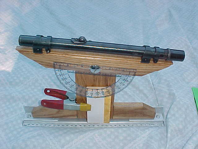
A telescopic alidade with brass ruling edge and rifle scope sight [picture]
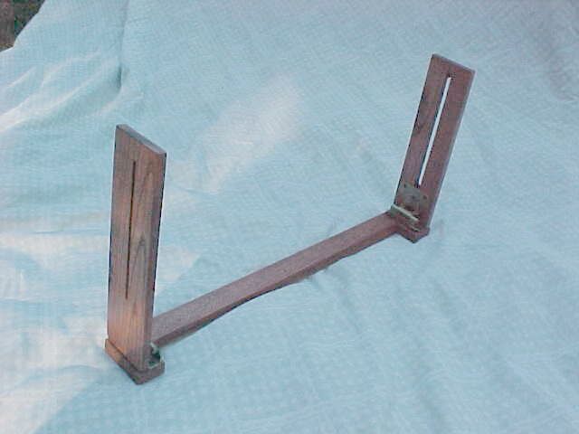
A prototype large compass, testing methods [picture]
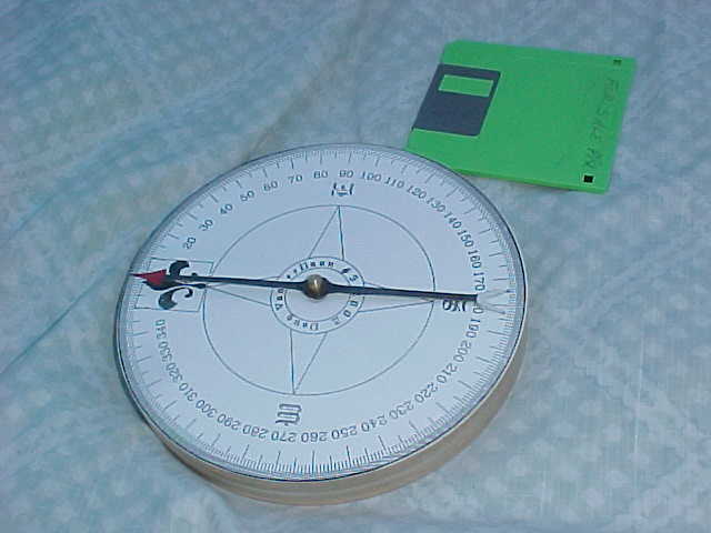
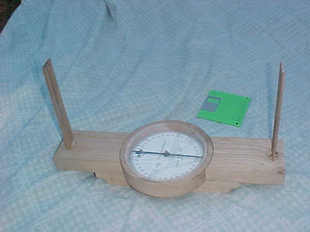
A wooden surveyor's compass with (temporary) sight vanes [picture] , but not finished yet It is 15-1/4 inches long. The frame arms are 3" wide and 1-1/8" thick, made of oak from an old pallet I recycled. The wooden "compass box" is 6-1/4" diameter and the needle is 5" long. The sight vanes are 6-1/2" high and 1-1/4" wide. The needle is made from a piece of used hacksaw blade, as was the one on the other compass.
A 90 degree surveyor's cross prism [picture]
A plane table and tripod. No picture. The table is an old wooden drawing board from my college days, about 18" by 24" and I made a tripod mainly from a piece of 2x6 ripped into 6 pieces for legs. Then later I was able to buy a real plane-table tripod with tilt and swivel Johnson head.
I've added a page with some information for making compasses. No real details or how-to, but scans of pages from several old books describing the construction of naval and surveying compasses, and some information on steels for compass needles.
Here's a book I highly recommend:
Latitude Hooks and Azimuth Rings - How to Build and Use 18 Traditional Navigational Tools
By Dennis Fisher, International Marine/McGraw Hill, 1995, $19.95, ISBN 0070211205
Its projects are mostly pretty simple and basic, but there are also some interesting ones such as an octant and a backstaff.
Field Measurements
I've heard from a few people who want or need to find their lot lines or corners. One had a map and had located one corner, but the lot description was based on compass directions. He had rented a transit but could not get one with a compass. Well, all a transit or theodolite can do is measure angles, so he needed to find north accurately, or else find another corner marker in the ground. Another person wanted to know about where to find a compass accurate enough to read to less than a half degree, for a similar purpose. I couldn't really help either one.
Since then I've run across some information in my old surveying textbooks and even some in a new surveying textbook. There is more than one good way to determine North accurately from the Sun.
And I found some information on checking and adjusting compasses, adjusting sextants and checking and adjusting a transit. Click the links to see the pages I scanned.
Transit Adjustment from "Surveying Manual, 4th ed." by W. Pence and M. Ketchum, from 1915,. Page1, Page2, Page3, Page4, Page5, Page6, Page7
Transit Adjustment from "Surveying" by Boucher (from 1946), Page10, Page11, Page12, Page13, Page14.
Compass Adjustment from "Surveying Manual, 4th ed." by W. Pence and M. Ketchum, from 1915, , Page1, Page2, Page3, Page4
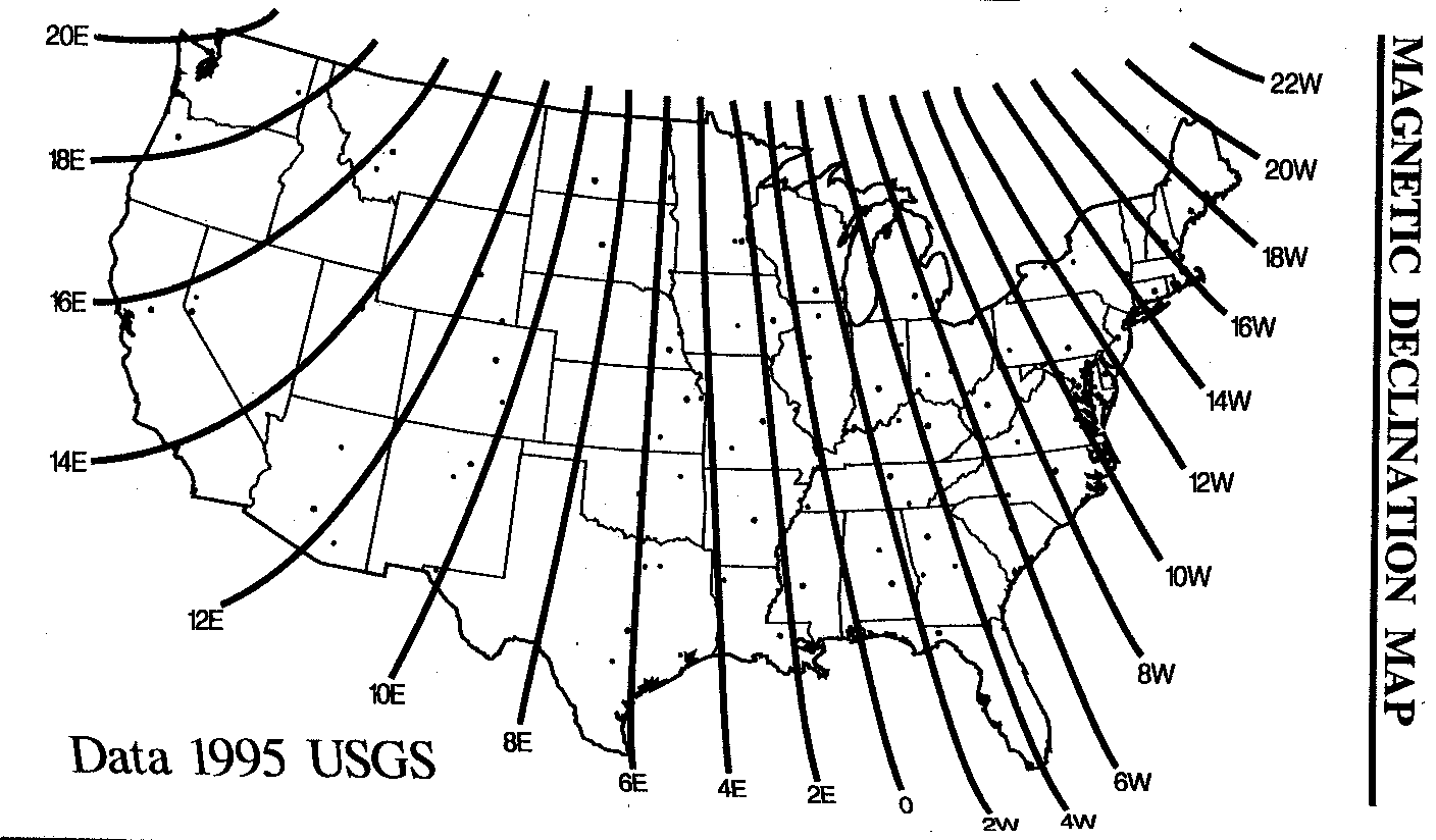
And a USGS map of Magnetic Declination also for those who need to know where True North is.
I ran across an interesting article from a professional surveying magazine (on its website) about determining true north from the North Star, Polaris, in the daytime!
<<The Advantages of Polaris Observations in Land Surveying.url>> http://www.cadastral.com/cad-polr.htm
Otherwise, you have to do it in the evening, when you can see Polaris but there is still enough light to operate the transit, read its scales and see the cross hairs.
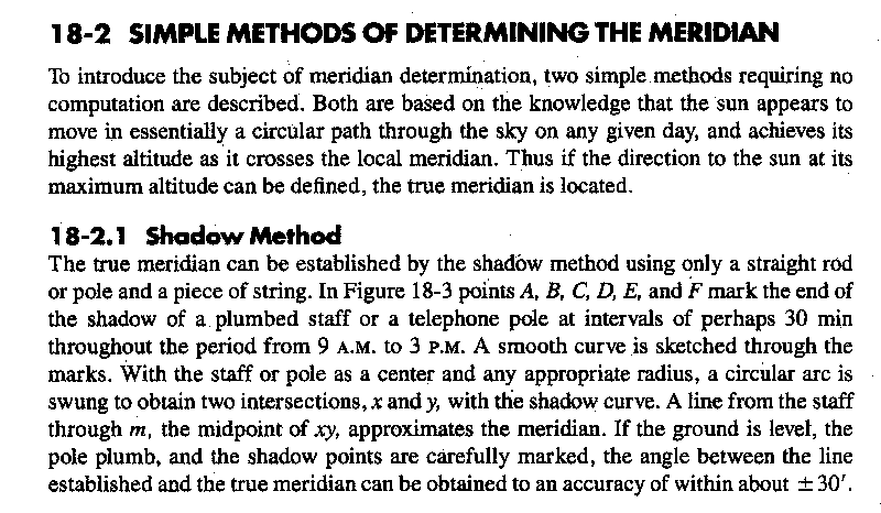
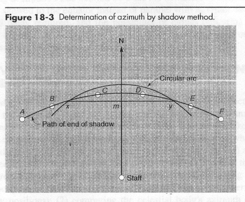
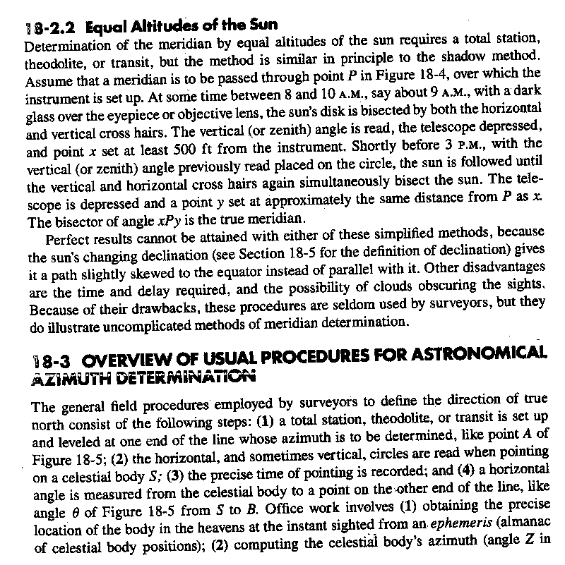
"Elementary Surveying" by Wolf and Brinker, ninth edition, has a section on "Simple Methods of Determining the Meridian." The are the Shadow Method and Equal Altitudes of the Sun. The shadow method requires only a straight rod or pole and a piece of string! And a few hours on a sunny day, of course. The Equal Altitudes method needs a transit with solar filter. Don't try it without one - looking at a magnified image of the sun will blind you before you can realize it.
Shadow Method text, Fig 18-3 (225k), Equal Altitudes text, Fig 18-4 (320k), Practical Suggestions for Polaris Observations.
There is an interesting method in "Instructions to Surveyors. " I borrowed the library's copy to scan but it's just not clear enough. Those pages seem to have come from a poor photocopy of a faint original. I'll try to type it out and add it when I get the time and ambition. Better yet, buy a copy of the book. The book is Special Instruction to Deputy Surveyors in Michigan 1808-1854 by Ralph Moore Berry, $40.00 plus shipping from http://www.surveyhistory.org/gift_shop1.htm
A probably similar book is" A Collection of Original Instructions to Surveyors of the Public Lands "- Item #520 from Professional Surveyor https://ns1.profsurv.com/item_display.php?x_item_id=24
(1980) Roy Minnick, ed.; HC; 580 pp; Item #520 $60.00
Contains 17 sets of original instructions beginning with those issued by Tiffin in 1815 and ending with the general instructions issued in 1881. Includes unique "Oregon Instructions" issued in 1859. Reduced sizes of maps and diagrams. This book is a collection of original instructions issued to surveyors of the public lands, beginning with those issued to Edward Tiffin in 1815 and ending with the General Instructions issued in 1881.
They have a number of interesting books for sale, at https://ns1.profsurv.com/category_list.php?x_category_id=1
For finding lot lines with a transit that has no compass, you need a way to find True North. This website can help.
Map Making
Plane Table Mapping
Get CHAPTER 9 PLANE-TABLE TOPOGRAPHY AND MAP PROJECTION (962 kB) from
http://www.advancement.cnet.navy.mil/products/web-pdf/tramans/bookchunks/14070_ch9.pdf
and Use of the Plane Table (99kB) from
http://130.39.236.59/redlingdir/2307/equipment/planetable/planetable.pdf
Elements of Surveying and Surveying Equipment from http://www.tpub.com/engbas/11.htm
And also see Engineering Basics at http://www.tpub.com/engbas/ for lots more engineering information, including "Plane Table" at http://www.tpub.com/engbas/11-24.htm
Map Making and Archaeology
There's a nice tutorial article at
http://spacegrant.nmsu.edu/lunarlegacies/archaeological_mapping.htm
Map Maker Gratis - the
free GIS for Windows availableAt http://www.mapmaker.com/products.htm
Recommended Books
"Map Making" by Frank Debenham
I had this one from the library, twice, and really liked it. It took a while but I found an inexpensive copy on ebay. I have also seen it listed on http://www.abebooks.com/ but postage from England would cost about twice as much as the book. It's pretty old and hard to find, but it's absolutely fascinating. Reading it was the main thing that got me hooked on learning about mapmaking and actually trying it myself. He's a great writer and the book is aimed at the amateur, not professionals. It's also for field scientists like geologists, archaeologists and foresters.
"Mapping" by David Greenhood
I also had this one from the library, and already bought my own copy through ebay.
Spier, R. F. "Surveying and Mapping: a manual of simplified techniques", Holt, Reinhart, Winston, NY, 1970
Again, I found this at the library, and it's great. I couldn't find any copies available to buy, but it was only 84 pages, so I photocopied the whole thing. With a slight reduction, 2 pages fit onto one copy sheet.
Low, J.W. "Plane Table Mapping" Harper, NY, 1952
This one I found out about from someone else's 'recommended' list, and saw it briefly at a college library where I couldn't check it out. There's another college library where I can check it out, and I do plan to.
Maps & Compasses, A User's Handbook, by Percy W. Blandford, 244 pages, card covers, 8" x 9", published by Tab Books, first edition, 1984. This is a handbook that contains everything you need to know about the use of maps and compasses. Assuming no prior knowledge, this guide takes you through a step by step process of map reading and compass use. Also talks about map making and orienteering.
While mostly about map reading, there is a pretty decent chapter on making maps, including using a plane table. And he has a diagram of a really simple to make sighting alidade, too.
Our library has this one, too. It's better than the usual TAB book, and pretty good for a Blandford book. I stole the description text from an ebay sale listing (the book didn't sell, at $6.95 + $2.50 postage).
Other books I've seen at libraries, which may also be useful (but seem less interesting to me) are
W. Ritchie et al, "Mapping for Field Scientists";
F. Monhouse & H. Wilkinson, "Maps and Diagrams, Their Compilation and Construction."
Other info sources:
I was looking for surveying info to help a reader of this page who had a problem and found a very interesting site called Manthey on Historical Surveying
He has pages about "How to Make a Gunter's Chain," "Make Chaining Pins ," " How to make Staves, Offset Staff, and Cross ," and a large collection of photographs of old surveying instruments. And there is a page for "The Practical Surveyor" by Samuel Wyld This is a guide and instruction book that was written in 1725. He has arranged to have the book reprinted. ($14.95). It is a splendid guide of how surveys were performed in the field. I was able to get a copy through inter-library loan and found it to be very worthwhile. I recommend it.
An Army and/or Marine Corps manual, FM6-50, calls its chapter 5 "Hasty Survey Techniques." You can find the manual on a couple of military web sites, in HTML and PDF format. Use Google to look for "FM 6-50" and look for military sites in the results.
HELP!
I now have a Wild T1 theodolite, but it's damaged in shipment. The horizontal 360 degree reading glass circle came loose. I need to find out how to accurately re-install it. The difficulty I have is getting it accurately centered. If you can help, please email me!
I'd be glad to know what you were looking for that brought you to this page, and to know what you think about it.
On November 23, 2002 there were already 112 hits since Nov 1st. Since it's a pretty new page and I hadn't thought the subject would be very popular, I'm curious about who reads it. There were 366 hits on this page in December 2004.
Click to email me.
---home ---------- Created August 21, 2002 - updated January 2, 2008